Sunday, May 27, 2012

Our Visit to Chagos - Gary


The BIOT administrators allow yachts to visit Chagos under permit, although clearly the bureaucrats in London do not place us in high regard making it harder and harder to obtain one.   They are continuously raising the bar on conditions .  By contrast the Royal Marines who are charged with policing the islands were charming, welcoming hosts.  

Two atolls are made available to visitors, both of which were previously settled by Chagosians, specifically Salomon and Peros Banhos.  Diego Garcia (where the military base is) is closed for security reasons, and all the other atolls are closed to facilitate nature conservation.

We stayed at Salomon anchoring directly off Boddam Island where the atolls settlement once stood. Of the anchorages made available this offers by far the best protection.

Map of Chagos (British Indian Ocean Territory) and aerial of the anchorage of Boddam Island (you can see yachts anchored).  This is where we stayed.


As you might have guessed from my introductory piece, the aspect of our stay I found most fascinating was the story of the Chagos Islanders and the remnants of their material culture slowly being reclaimed by the jungle.  We were lucky, a fellow yachtsman gave us a series of annotated photos collected by British scientists who have carried out extensive natural history surveys in the BIOT – this is the source of the old photos presented here.  The regrowth is so thick that it is now impossible to replicate the camera angles used.

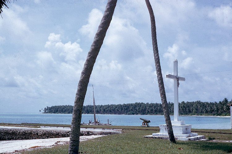
1963.  The Boddam Island settlement taken from the jetty.  Behind the tree is the manager’s house, and on the right a cross and copra godown.  Copra was transported between the processing areas, godown and wharf on donkey drawn railway cars.

2012.  The same cross, surrounded by lush regrowth (A party of Chagossians was permitted to return for a visit in 2006 and again in 2009 and have obviously undertaken maintenance of selected sites including this cross).


2012.  The remains of the copra godown and railway.


1963.  In the background are crushing/pressing units?? (there are two, one looks like a big hammer on the right of this photo with a bit of galv iron on top at an odd angle), a flag pole, copra drying area (the series of low roofs behind the wall), church (obvious), and hospital (building with verandah to right of church).


2012.  These are the crushing/pressing units (??) captured in the above 1963 photo. In some notes we have is a reference to the use of donkeys for pressing oil from the copra.  These cast iron vessels are securely bolted to a concrete pad set in low circular stone plinths, and both have drain holes low down (crab home).  As you can see, whatever they once were they make good yachty incinerators.


 Flagpole support.

2012.  Remains of the church and hospital (bottom right).  The church is the best preserved of all the buildings

1963. Boddam jetty.

2012. Boddam jetty.


1963.  Boddam residents, boat shed and copra godown.


2012.  Remains of the boat shed, now the yachtee laundry and clothes drying area 


1978/79.  Boddam managers house, still standing when this photo was taken it is now no more.  Built almost entirely of timber, all that remains is the coral stone plinth which once supported the verandah.


2012.  Boddam cemetery.


Scattered through the bush are the remains of many other buildings including the school, goal, and workshops, relic machinery and quite a few surviving exotic garden plants and trees.


PHOTOS
Thanks is extended to the other photographers which may or may not include:
Chas Anderson, Kirby Crawford, David Dixon
Mont Hirons, Rebecca Klaus, Ted Morris
Goetz Reineke, Charles and Anne Sheppard
Mark Spalding, Donald Taylor, John Topp

- - -

The Chagosians – my summary of their story - Gary


Every place has its human story – but none more strange or tragic than that of Chagos and its people forced in to exile in the early 1970s.

“A shocking recent act of imperial arrogance”
is how one journalist has described the hand the UK and USA sprang upon the unsuspecting Chagosians.

The Islands
Chagos is an archiplelago of 65 tiny coral islands surrounding a series of atolls and lying dead centre of the equatorial Indian Ocean.  First settled in 1793 (only 5 years after the First Fleet brought European settlers to Australia’s Botany Bay) the New Chagosians were slaves and lepers, brought to these islands from Mauritius to establish coconut plantations.  Emancipated in 1838, the former slaves were at intervals joined by fresh waves of emigrants from Africa, Madagascar and India to work company plantations.

The Culture
The archipelago, for most of its settled history, has been administered by the British, first as part of the Seychelles and then as part of the colony of Mauritius.  The plantations were held under lease and then as freehold, first by a Mauritian Company, and then by a wealthy Seychelleese family company.  The Chagosians were essentially company employees or their dependents.  Workers were paid wages (mostly in the form of basic goods and provisions), but also limited cash, held for individuals until sufficient had accumulated for them to travel to Mauritius to purchase additional needs.  Families maintained gardens for fresh fruit and vegetable, raised chickens and supplemented their diet by fishing.  Ships came regularly, delivering mail and supplies and taking the coconut products.  Settlement focused on three main towns on the atolls of Diego Garcia, Salomon and Peros Banhos where copra processing and storage facilities and wharfs were located.  Community facilities included schools, churches, hospitals and graveyards.  At its peak, around 1970, the population numbered around 2000 people.  The Chagosians had by then evolved their own distinctive language and culture and many could trace their lineage back to the earliest days of settlement.  The Chagosians might be considered just company employees (of a company likely headed for bankruptcy), but increasingly they were also gaining many of the characteristics of nationhood. But things were about to change.

A Strategic Neccessity
In the midst of the cold war, with the British withdrawing from Asia and closing bases in Sri Lanka and the Maldives, the US decided upon the strategic necessity of an Indian Ocean base to protect the flow of Gulf oil.  In 1964, following a feasibility survey, Chagos became the location of choice, but a US requisite was that it be sans Chagosians.  Mauritius was at the time a self governing colony moving towards independence, so a first requirement was for the British to decouple Chagos from Mauritius via a payment of £3 million.  So in 1965 the British Indian Ocean Territory (BIOT) came into existence – Chagos now had a new name!  In 1966 the British secretly reached an agreement with the US on a 50 year lease to develop any island of the BIOT for defense purposes.  In 1967 the British purchased all the plantation company’s BIOT assets from its Seychellian owners and progressively closed down the plantations and arrival of supply ships.  On April 1971 the UK quietly issued a policy called BIOT Immigration Ordinance #1 which made it a criminal offence for those without military clearance to be on the islands without a permit.  During that same year the US commenced construction of a major military base on Diego Garcia. By 1973 all the Chagosians had been removed, by force if necessary, from their homes, heritage and way of life, and their houses, stock and domestic pets systematically destroyed.

Without ceremony the now homeless, voiceless Chagosians were deposited upon the docks in either Mauritius or the Seychelles.  Largely destitute, with little education and not speaking the language of these host countries, the Chagosians were largely confined to the fringes of these societies, living in slums.  Many are still there.  But they have slowly developed a voice and are fighting back!

Fightback!
Some compensation has been forthcoming, first £650,000 in 1973 (though not distributed until 1978!) and then £4 million in 1982.  In November 2000 the UK High Court ruled that the expulsion of the Chagosians was unlawful and conferred on them the right of return.  But the Chagosians were going to need assistance to return and before this could happen, in 2004, orders were passed by the UK Parliament removing this right of return.  In 2006 these orders were overturned by the High Court, returning to Chagosians their right of return.  The UK government appealed this ruling but was defeated in the Court of Appeal.  The judges called the treatment of islanders “unlawful and an abuse of power”.  But the government still had a strong backstop, taking its appeal to the House of Lords, which in 2008 overturned the High Court.  The Chagosians again lost their right of return!  But still they fight on.

They currently have at least two more irons in the fire.  The Chagosians have taken their case to the European Court of Human Rights and await a judgment there.  The UK government, dogged to the last, has chosen to continue to fight on rather than reaching a ‘friendly settlement’ as this jurisdiction proposed.  As well on 4 April 2012 a petition was lodged with the US White House asking the US to consider the plight of the people of Chagos.

Conclusion
I wonder that we ask some people in the world to pay too high a price for the charmed existence us Westerners enjoy. Certainly as a family we all agreed that if it was indeed necessary then the whole exercise could at least have been done a whole lot better.

The settlement of East Point on the atoll of Diego Garcia, as it existed in 1968 

Top: arrival of mail, bottom: husking coconuts, both Diego Garcia 1963 


Approaching the military base ‘Camp Justice’ on the atoll of Diego Garcia.


Photos of the base taken between 1986 and 1999.  The base is now the only place of human habitation remaining in the BIOT.


PHOTOS
Thanks is extended to the photographers which may or may not include:
Chas Anderson, Kirby Crawford, David Dixon
Mont Hirons, Rebecca Klaus, Ted Morris
Goetz Reineke, Charles and Anne Sheppard
Mark Spalding, Donald Taylor, John Topp

- - -


Gan, Maldives (by Gary)


We hadn’t planned on going to the Maldives, a nation comprising 162 coral atolls encircled by 1192 tiny islands.  Not terribly yacht friendly is the reputation.  A cruising permit costs around a US$1,000, which didn’t seem great value, particularly because we’d heard that the over 100 tourist resorts - scattered through the prettiest, most sheltered locations - make it clear they do not want yachts parked out front.

But the passage south from Sri Lanka is notorious for light wind/no wind, and it seemed as if a refuelling stop would be good.  So when we heard that a much cheaper 3 day or slightly more expensive one week option was possible in the southern most island of the southern most atoll we went for it.  This is what brought us to the island of Gan, Addu Atoll.

And what a surprise it has been!  The town (Addu City!) is just delightful.  It is easily the cleanest, tidiest, calmest place we have seen in all of Asia.  No touts, no garbage, no stink of effluent, no suicidal traffic, no press of humanity wanting to make a withdrawal from us, the walking ATMs.  Just equatorial peace and tranquility.

Gan is typical of islands surrounding atolls, it is tiny (2.25 km²), flat and barely above sea level – the Maldives is reputedly the flattest nation on earth, with a maximum elevation of 2.3m.

Easily the most bike friendly place since Cairns Qld – we rode everywhere, even at night. 


Gan is the site of a former British navy and airforce base – first established during WW2 the British only withdrew in 1976.  Military’s barracks, officer housing, mess halls and godowns still survive.  Most have been recycled for other purposes – including for a budget resort.  The airfield is now an international airport supporting the tourist industry – by far the most important sector of the Maldivian economy.


A series of causeways (another legacy of the British) link the four most populated islands of Addu Atoll together.  

The backstreets of Addu City (pop. about 30,000) are a fascinating maize of narrow, crushed coral laneways lined with little houses and walled gardens – many constructed of coral rock.


The CBD of Addu City is a bit hard to pick – left above is the ‘high rise’ section.  Taken early morning, it was mostly deserted as are most of the town’s cafes and restaurants.


Everywhere around town are these amazing steel framed public seating areas, but in the heat of the day they are deserted!


But come the cool of late afternoon the town comes alive!


The towns cafes and restaurants fill up ...


... the public seating is suddenly near capacity...


... and the footpaths become the locus of fierce competitions.


But just in case you think it’s all tropical paradise – think again.  Civil unrest often bubbles just below the surface in the Maldives.  Just weeks before we arrived the democratically elected government was toppled by a police supported coup.  The community of Addu City was so incensed they rioted, torching the city’s several police stations and some other public buildings.


- - -


Saturday, May 26, 2012

Sri Lankan Transport – by Vicki


Transport in Sri Lanka comes in many shapes and sizes, they vary from plain to colourful and some are highly accessorised. Most vehicles have horns that are frequently used. Speed is not a determining factor in choice of transport given that the maximum speed limit is 60km, except on the nations single tollway where the limit is 110km.

Buses
Buses are kings of the roads. Buses are the most common mode of transport in the urban fringe, outside towns and in rural areas - they are large, arthritic old rust-buckets, cheap, noisy and often very crowded. They toot as they are about to pass, heading for any gap in the traffic...watch-out!

A miss is as good as a mile!

Tuk-tuks
Short trips in cities, towns and villages are usually undertaken in tuk-tuks. These three wheeled vehicles are made in India and are mostly red, green or black. We had fun tuk-tuk spotting and also saw florescent green, blue, yellow, orange, metallic pink, purple, beige, white and turquoise. Tuk-tuk spotting also extended to accessories and adornments, such as: florescent stickers and slogans; flowers; coloured LED lights; multiple mirrors; boom boxes; twirly chrome handholds and driver barriers; and roof racks carrying surfboards.

There is no limit to the number of people a tuk-tuk will carry – arms and legs inside please. Our family used them for city shopping and even a day tour around Galle’s main roads, back and side roads. We found them convenient and fun and enjoyed weaving through the traffic and (sometimes) up streets the wrong way. They are amazingly strong – toting four of us and our driver up some short steep hills. Prices for a tuk-tuk are negotiated, by the kilometre or by the hour. In Galle we generally used the same tuk-tuk driver and paid 400Rs per hour.

In every town or village tuk-tuks will line up, competing for fares. Major events like the England versus Sri Lanka Test Match (March 2012) saw the tuk-tuks lined up two and three deep encircling the cricket ground.


Move it, move it.
Trucks in Sri Lanka fall into two categories – modern monochrome or those that are older and individualised. Rural transport carriers with their box sides provide multiple surfaces for artistic expression – colour dominates and also utilises the company name in the design. We enjoyed seeing these slow trucks on our travels across the lowlands and highlands of Sri Lanka.

One of the more unusual transport carriers, though common in Sri Lanka, were the cultivator front-ends with trailers. These small machines could haul large loads of rice – we marvelled at how large some were. These carriers could also be seen in urban areas and in rural environs.


- - -


TEA - A Report by Zeke


Monday, April 9, 2012

Gary: Sri Lanka


A signature Sri Lankan animal – the hooded cobra.  They really hiss too!  Sri Lanka has something like 87 snake species, and many are highly venemous.  The nation suffers more deaths from snake bite, per capita, than any other.  And yes this photo was taken with our camera.

We always make an effort to understand something of the countries we visit, even if it is a very superficial appreciation.  National characters, if indeed they exist at all, are neccesarily complex.  And never more so than with Sri Lanka – the most amazingly complex country we’ve ever visited.

A trivial but perhaps insightful example of us getting acquainted with Sri Lanka grew out of three simple tasks I needed to do while in the Port of Galle, viz:

  • take our old 4hp Mercury to an outboard mechanic for repairs
  • take an even older hand cranked Singer to a sewing machine mechanic for repairs
  • take some plastic jerry cans out to the local servo for refilling with diesel fuel.

The Port of Galle from Mojombo’s deck.  
 It’s a busy working port.    
The port is under the control of various arms of the Sri Lankan bureaucracy including (but certainly not limited to) the navy, police, customs, harbour master and port security service.  Visiting yachts require an agent to negotiate its minefield like complexity.  

To undertake my three tasks our agent first prepared a letter (shown below), which he circulated for approval with four separate government departments in the port.  The outboard, sewing machine and jerries, along with the letter, then had to be thoroughly scrutinized and discussed by all parties while departing and later returning to the port.  To expedite matters eight copies of the letter were handed out to the various officials, including the two sequential boom gates, manned by seperate departments at the port entrance.


The letter, signed by four government departments, authorizing me to take an old outboard, sewing machine and plastic containers out of the Port of Galle.

The goods aboard our agents vehicle, returning to the port with me
in the cab clutching spare a copy of the letter.  Our agent has
stepped out the cab to negotiate with boom gate staff.

This whole process could however have been easily short cut had I chosen a different path.  Payment of a small bribe or two to the right officials would have truncated the process to minutes instead of days. It’s mind boggling wondering how a country can function when saddled with such a heavy, lazy, complex, inept and corrupt civil service.  But deeper insights yet were available.


One of the reasons for the Galle bureaucracy’s preoccupation with port security (and its fatness and laziness) is that it is only a few short years since the country emerged from a long and bloody civil war – when it really needed lots of tight security at its ports.  This war was fought between the dominant Sinhalese and a group of militant Tamils in the north, very roughly characterized as follows:
  • Sinhalese make up 74% of the nation’s population, consider themselves ‘native’ Sri Lankans, are primarily Budhists, speak Sinhala, and first arrived from northern India about 500BC.
  • Tamils make up 18% of the population, are Hindus, speak the Tamil language, and arrived from southern India right through from prehistoric times to the English tea plantation era, when large numbers were brought in as field labourers.

While officially the war started in 1983 and ended in 2009, it is a conflict that has its roots buried in literally thousands of years of history, migration and conflict with its closest neighbour, India.  Each side in the war claims underdog status and dreadful atrocities litter both camps.  Many consider it will be close to a miracle if a lasting peace emerges.  The pot was well stirred during the colonial era, which drew to a close in 1948, leaving among other things the legacy of a huge tea industry, the world’s largest (and best known!), and by far the country’s biggest export earner – but equally an industry dominated by issues of equity, caste and ethnicity.

The tea plantations back then were large land holdings spreading across the country’s best, most fertile soils.  They were largely owned and managed by companies and individuals from England. They, along with the large rubber and coconut plantations had been created through the massive displacement of Sinhalese rural peasants – leaving a miasma of simmering discontent.  To address the issue during the 1970s the government nationalized the big estates, redistributing the land from some while managing others as government cooperatives.  This wonderful socialist experiment predictably failed, and much of the industry has subsequently been returned to private ownership following the collapse of tea yields, quality and market share (and hence export earnings).

Morning mist hangs over a highland tea plantation 


Top left: Tamil tea pluckers hard at work.  Bottom right:  the pucker sahib ‘Hill Club’ in Nuwara Eliya, where the colonial ‘planters’ spent many a pleasant evening.

The socialist leanings of the country - Sri Lanka is officially known as the Democratic Socialist Republic of Sri Lanka - also does much to further account for the enormous, unproductive civil service.  Being pathetically paid (the service is too large to be otherwise), civil servants frequently feel forced to resort to corruption, and are often just following the example of their political masters.  The seeds of this corruption have sewn themselves deep into Sri Lankan society creating a citizenry that often seems tightly focused on whatever advantages they can accrue to themselves and their direct dependents, especially when dealing with foreign tourists.

But if these impressions sound overly negative they sell the country way short.  Sri Lanka is an amazing place.

People of Sri Lanka

It is fertile, lush, and green. The lowlands are steamy hot, the highlands refreshingly cool and mist shrouded.  In places it is overflowing with wildlife.  It is one of the few places left on the planet where you can still see a leopard in the wild – we did.  Wild elephants roam its national parks, blue whales swim just off-shore.  It’s a bird watchers paradise.

Wild elephants roaming in one of the nations excellent, seemingly well managed national parks


The amazing biodiversity of Sri Lanka

Steeped in ancient culture, the remains of magnificent ancient cities, some dating back well before the birth of Christ are on display at several UNESCO listed World Heritage Sites.  Intact colonial architecture litters the country.

Spectacular Sigiriya – the Lion Rock.  A 5th century fortress palace blending astonishing works of architecture, landscape architecture, engineering and art. A World Heritage Site.

Galle Fort:  A largely intact colonial cityscape left by the Dutch and English – another World Heritage Site.

The country is awash with a colourful parade of humanity practicing a wide range of traditional pursuits, many little changed for hundreds of years: rice farmers, oxen drivers, smithies, tailors, fishermen, gem miners, and gem cutters and polishers.


Oxen drivers!


Bringing in the rice harvest for threshing


Gem cutter


Stilt fisherman


Sri Lanka can be a difficult and sometimes tiresome place to visit, especially if you’re a yachtee, but we found the effort paid big dividends.